Archive
Sentinel-1A Satellite: Transforming the analysis of earthquake data
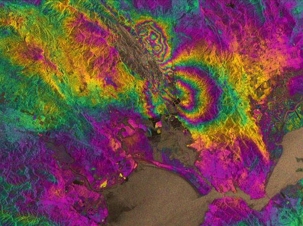
We’ve previously written about the launch and progress of the Sentinal-1A satellite, part of the European Union’s Copernicus earth observation project. Although still being commissioned and not yet in full production mode, the satellite recently provided radar imagery from Northern California captured before and after the Napa Valley earthquake on 24 August.
Using a technique known as ‘Synthetic aperture radar interferometry’, two images of the same area were compared to identify areas of significant change. Changes to the ground surface modify the reflected radar signal detected by the satellite, and those modified signals can be plotted as an ‘interferogram’ (Source: Radar vision maps Napa Valley earthquake.) The result is both colourful and striking; the fault responsible for the 6.0 earthquake was confirmed as the West Napa Fault, and both the scale and the extent of the surface rupture was immediately apparent.
Imagery like these examples captured for the Napa Valley quake looks set to transform how scientists and data analysts map and respond to earthquakes. With the launch of second Sentinel satellite (1B) in 2016, the imagery update cycle will be reduced from 12 to 6 days. The timely and open publication of high resolution data to support activities on the ground and post quake analysis after each event, should provide unprecedented monitoring of the Earth’s surface.
Update on the Sentinel-1A satellite
In April we wrote about the launch of the Sentinel-1A satellite, part of the European Union’s Copernicus Earth Observation project, and the plans to make the data publicly available. Although the satellite is still being calibrated and not yet fully operational, it has already provided some radar data to help support the recent flood mapping activity in the Balkans. As the radar on-board Sentinal-1A can operate through cloud, rain and in darkness it is especially useful for monitoring floods.
After persistent heavy rainfall resulted in widespread flooding and a number of landslides in Bosnia and Herzegovina, the emergency services needed access to accurate and current maps of the region to support the relief effort. The data from Sentinel-1A helped identify areas of flooding that the emergency services were unaware of.
The Sentinel-1A satellite has also helped monitor flooding when the Zambezi River burst its banks in April, inundating the border between Namibia, Zambia and Botswana. Data from the satellite were made available to the Namibian authorities within three hours of collection, providing near real-time information for an area had been difficult to survey on the ground.
Given the impact Sentinel-1A has already had, the Earth Observation project looks set to make a major contribution to environmental monitoring and assessment. The satellite will soon be fully operational, helping to provide some of the data that will support a more holistic approach to environmental management.


Recent Comments