Archive
A Top 10 List of Useful Geospatial Data Portals
We have been writing this geospatial data column since 2012, when our book The GIS Guide to Public Domain Data, was published. Over the 5 years that have elapsed, in addition to keeping issues such as data quality, copyright, privacy, and fee vs. free at the forefront of the conversation, we have tested and reviewed many geospatial data portals. Some of these portals promise more than they deliver, some have been frustrating, but some have been extremely valuable in GIS work. We have decided to list 10 of those that we have found most useful, rich with content, easy to use, and with metadata that is available and understandable. In considering such a list, we realize that “most useful” really depends on the application that one is using GIS for, but the following sites should be useful for users in many disciplines. Some allow for data to be streamed from web servers into your GIS software, and all allow data to be downloaded.
- The FAO GeoNetwork. This portal contains global to regional scale data from administrative boundaries and agriculture to soils, population, land use, and water resources.
- The Esri Living Atlas of the World is an expanding, curated set of data and maps on thousands of topics that can be used and also contributed to by the GIS community.
- The European Space Agency’s Sentinel Online data portal includes a wide variety of image-related data sets on the five themes of land, marine, atmosphere, emergency, and security.
- CIESIN at Columbia University has been serving data for over 20 years on climate, population, soil, econonics, land use, biodiversity, and other themes, including its Socioeconomic Data and Applications Center (SEDAC).
- The Global Land Cover Facility at the University of Maryland remains one of the best and easiest to use sources and methods to obtain Landsat, MODIS, Aster, SRTM, and other satellite imagery.
- The Atlas of the Biosphere serves global data, largely in grid format, of human impact, land use, ecosystems, and water resources themes.
- Natural Earth is a public domain dataset at small scale (1:10,000,000, 1:50,000,000, and 1:110,000,000) for the globe, in vector and raster formats that are easily ingestible in GIS software.
- The World Resources Institute hosts a variety of data geospatial data sets for specific areas of the world, such as Kenya and Uganda.
- The GIS Data Depot from the GeoCommunity is one of the oldest data depositories, dating back to the 1990s, but still very useful for international and USA specific data on such themes as elevation, transportation, imagery, scanned topographic maps, and hydrography, many of which have been re-served from more-difficult-to-use government sites.
- There have been many “lists of data sites” over the years, and these invariably are not kept up to date and end up being less useful over time. However, those that are still quite helpful that we have reviewed are Dr Karen Payne’s list from the University of Georgia, and Robin Wilson’s list of free spatial data. A few others that are useful are this list from the USGS that I started back when I worked there, and this list from Stanford University.
A few selected others are also useful that “almost make the top 10” above are The National Map from the USGS, data.gov from the US Government, environmental and population data from TerraPopulus, Diva-GIS’s data layers for each country, the UNEP Environmental Data Explorer, the NEO site at NASA Earth Observations, and OpenStreetMap.
For more details on any of these resources, search the Spatial Reserves blog for our reviews, remain diligent about being critical of the data you are considering using, and as always, we welcome your feedback.

A Top 10 List of Useful Geospatial Data Portals.
Sharing Geoprocessing Tools on the Web
An article co-authored by Benjamin Pross, Christoph Stasch, and Albert Remke, of the 52°North Initiative for Geospatial Open Source Software GmbH; and Satish Sankaran and Marten Hogeweg of Esri describes a development that should interest anyone who uses geospatial data. The 52°North Initiative for Geospatial Open Source Software has developed an open-source extension to ArcGIS for Desktop that enables access to Open Geospatial Consortium, Inc. (OGC), Web Processing Services (WPS). The result? This initiative makes it possible for these services to be used in the same manner as native ArcGIS geoprocessing tools. In other words, they appear in the list of tools just as a standard buffer or overlay tool would appear. Yes, it could be just that easy.
The article explains that “while ArcGIS allows geoprocessing tools to be published as a WPS, [ArcGIS] does not offer a WPS client interface. Consequently, it is not easy to access external non-ArcGIS geoprocessing tools such as simulation models, rich data interfaces, or processing capabilities from any other legacy software that supports the WPS interface.” This points to the reason why this initiative offers such promise: “The 52°North Extensible WPS Client for ArcMap was implemented as an open-source extension to ArcGIS that fully integrates into the ArcGIS for Desktop environment. It enables OGC WPS to be accessed and used in the same manner as native ArcGIS geoprocessing tools. This makes it easy to run WPS-based processes and integrate the results of that processing into ArcMap for use with other applications.”
In plain language, because the complex issues grappled with by GIS analysts often require major investments of time to generate models, services, and customized workflows and code, why should each analyst have to create all of this from scratch? An enormous time savings could be realized if there was an easy way to share these things. This article both explains recent progress in this area but also encourages the community to think creatively about how to pursue further collaborative methods.
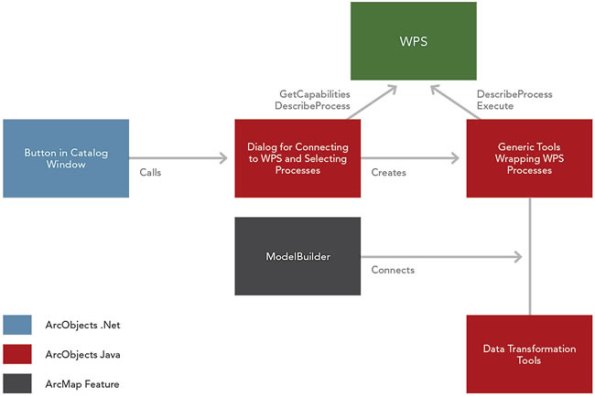
ArcGIS Web Processing Service client architecture.
Contributors
Gallery


Recent Comments