Archive
GIS Ethics site of case studies recrafted
The GIS Ethics site at Penn State University has recently been recrafted: https://sites.psu.edu/gisethics
With support from the National Science Foundation, The GIS Professional Ethics Project has produced this curated collection of geospatial ethics case studies available as Open Educational Resources at GISEthics.org (formerly GISProfessionalEthics.org). The Project also helped establish graduate ethics seminars on the ethical implications of geospatial technologies at Penn State, Oregon State University, and the University of Minnesota. This site has expanded to include 18 case studies, including a timely new case entitled “Flood Mapping” by urban planner Clarke Shupe-Diggs. There is also a new list of related case study collections, which we first wrote about earlier this year, here.
The site is well laid out and the contents are incredibly useful. As an educator, I found the section “How to Analyze Case Studies” particularly helpful.
David DiBiase, curator of the site and one of the principal investigators, is welcoming further suggestions to the site and recently posted, “Along with everyone who has contributed to this effort over the years, I hope the collection is useful to you.”

–Joseph Kerski
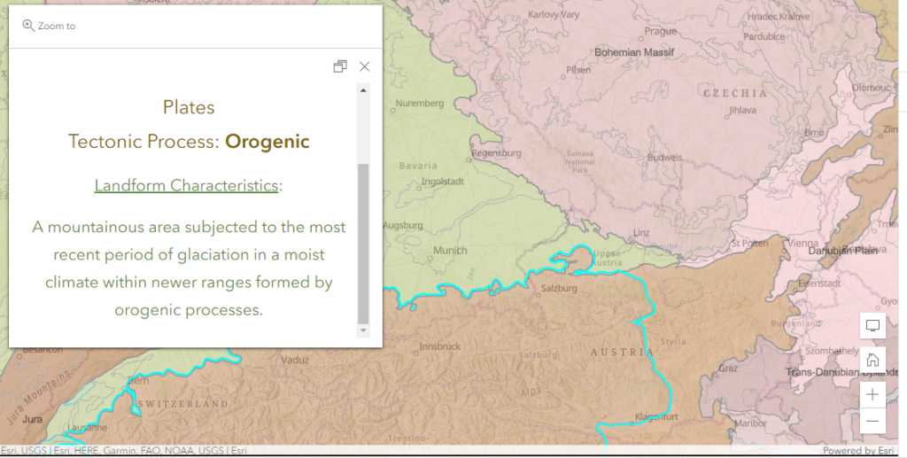
Updates to Named Landforms of the World data
My colleague, Esri Chief Cartographer Charlie Frye, has completed work on the updates to the Named Landforms of the World, version 2. This is now available in the ArcGIS Living Atlas of the World. The following essay serves as the best place to get started:
Introducing Named Landforms of the World, version 2 (esri.com)
Included in the data set are four global sub-layers representing landforms, provinces, divisions, and their respective cartographic boundaries. There are three ways to get started with this data:
- Explore the layers in the viewer instant app.
- Add the layers to your own web map.
- Download a map package for ArcGIS Pro for further analysis.
One of the contributors to this effort created this informative story map with information about landforms and adding tectonic processes to landform data.
This data set is based on core science, is authoritative, well documented, and fills a much needed gap in global spatial data. In my opinion it is excellent for use in research and in education. Landforms are a cross-disciplinary theme that can be used in land use, population, climate and weather, hydrologic, and other studies.
I highly encourage you to examine and use this newly improved data set!
–Joseph Kerski
Contributors
Gallery


Recent Comments