Archive
Georeferencer Project: Crowdsourcing location data for historic maps
In 2011 the British Library set up the Georeferencer project to crowdsource the georeferencing of its collections of scanned historic maps. By adding georeference (coordinate) data to the old maps, they can be viewed alongside modern maps via the Old Maps Online data portal and the catalog of georeferenced maps.
Using illustrations extracted from digital books and public domain images posted on Flickr, many of the maps were identified and geo-tagged by a team of volunteers as part of a Maps Tag-a-thon event that ran from Nov 2014 to January this year. Among the collections of maps released so far are the Ordnance Surveyors’ Drawings (one inch to a mile maps for England and Wales 1780 – 1840) and the Amercian Civil War collection.
To date, over 8000 maps have been successfully georeferenced and quality checked by a panel of reviewers.
Track on Track: Reflections on GPS Accuracy on a Running Track
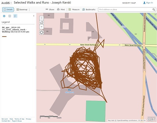
Recently, while at the Applied Geography Conference in Atlanta, I decided to test the spatial accuracy of my smartphone’s GPS in a challenging environment–a rooftop running track. Although located on a roof, the track was surrounded by buildings far taller, and in downtown Atlanta, a location with many other buildings impeding signals from GPS, wi-fi hotspots, and cell phone towers. A further challenge to the GPS positional accuracy was that each lap on the track was only 0.10 miles (0.16 km), and therefore, I would not travel very far across the Earth’s surface.
After an hour of walking, and collecting the track on my smartphone with a fitness app (Runkeeper), I uploaded my track as a GPX file and created a web map of it in ArcGIS Online. As I expected, the track’s position was compromised by the tall buildings–I only had a view of about half the sky during my time on the roof. As you can measure for yourself on the map linked above, the track lines formed a band about 15 meters wide, but interestingly, were more spatially precise along the eastern side of the track, where the signal was better, as you can see in my video that I recorded at the same time.
Also, as I have encountered numerous times in the past, a line about 100 meters long stretches to the north. Rest assured that I did not leap off the building, but rather, the first point that the GPS app laid down as I opened the doors to walk outside was about a block away. Then, as I remained outside, the points became more accurate. When you collect data, the more time you spend on the point you are collecting, typically the more accurate that point is spatially.
Another interesting aspect of this study is that if the basemap is changed to satellite imagery, it appears that the track overlaps the tall building to the west. Try it, using the map link above. However, a closer investigation reveals that this is a result of the orthocorrection that was performed on the imagery; the buildings do not appear from “straight overhead”, but rather, they “fall away” to the east. Turn this into another teachable moment: Images, like maps, are not perfect, but they are very useful. We can learn to manage error and imperfection through critical thinking and through the use of geotechnologies. This is a central topic of our book and of this blog.
To dig deeper into issues of GPS track accuracy, see my related post on errors and teachable moments in collecting data, and on comparing the accuracy of GPS receivers and smartphones and mapping field collected data in ArcGIS Online here and here.
Despite these challenges, overall, I was quite pleased with my track’s spatial accuracy, even more so considering that I had the phone in my pocket most of the time I was walking.
Inexpensive and crowdsourced remote sensing
In an article entitled “The Watchers”, David Samuels discusses a company seeking to deploy small satellites into orbit 500 miles (805 km) above the Earth. This company, Skybox, founded by ex-Stanford University students, seeks to shake up the commercial space imaging industry by doing two things: (1) Deploying smaller, less expensive satellites than what the commercial space imaging industry is currently using, the size of a dormitory room refrigerator, and (2) Using crowdsourcing for data classification. They seek to have ordinary citizens classify the incoming data, as well as do some classification themselves, even from images that the company has collected but does not sell. This could be the number of cars in every WalMart parking lot in the USA, the size of slag heaps outside the world’s largest gold mines in South Africa, and the rate at which the wattage along key stretches of the Ganges River is growing. These bits of information, they reason, are clues about the economic health of countries, industries, and individual businesses. Therefore, this information will be so valuable to investors, environmentalists, activists, and journalists, to name a few, that they will be willing to pay for the information. The company is working with the government of Russia for a launch vehicle and hopes to launch its first satellite this month, SkySat-1.
This story connects well with issues we raise in the book The GIS Guide to Public Domain Data, including data quality and resolution, military vs. civilian uses of data, crowdsourcing, and privacy. The resolution of the images returned from Skybox’s satellites will be comparable–less than 1 meter–to those from large commercial satellite imaging companies such as Digital Globe. However, the cost of constructing them should be considerably less and the size of the satellite itself considerably smaller. Skybox has added numerous advisers with connections in the defense industry “to avoid any military-industrial squelching of its technology before launch.” Relying on crowdsourcing to classify images is not a new concept, but what is new here is the scale at which it could be employed, and that it is embedded in the company’s business model. How standards will be established to assure data quality to potential purchasers of the derived information will be very interesting indeed. Lastly, the idea of inexpensive, high resolution, easy-to-deploy satellites imaging the planet has enormous privacy implications for those of us on the ground, whether from Skybox or for others who are sure to follow.
Geo-Wiki.org: Crowdsourcing to improve global land cover data
In our book The GIS Guide to Public Domain Data, we spend quite a bit of time discussing crowdsourcing, and rightly so: Over the past few years, crowdsourcing has become a viable way not only to collect data, but also to verify and update existing data. Reasons include budget constraints in those agencies that provide data and the subsequent need for field verification, a growing recognition that decisions based on spatial data are only as beneficial as the accuracy of the data sets themselves, the rapid expansion of citizen science, and growth in the number and variety of mobile and web-GIS tools that enable citizen scientists to contribute to the global community.
Examples of verifying and updating existing data are numerous, and a noteworthy one is from a group of researchers at the International Institute for Applied Systems Analysis (IIASA) in Austria who lead an effort to improve global land cover/land use data. This effort, http://www.geo-wiki.org, verifies three land cover data sets, including GlobCover from the ESA, MODIS from NASA, and GLC 2000 from the IES Global Environment Monitoring Unit, through knowledge and photographs from people local to specific areas.
Besides an improvement of the data and, it is hoped, in the decisions based on those data, some of these efforts feature innovative projects that provide benefit to local people. For example, Geo-Wiki users were asked to identify the presence of cultivated land and settlements in samples in Ethiopia in a “hackathon” associated with USAID in an effort to improve local food security.
More information can be found on the Geo-Wiki site and in an article describing the project.
The GIS Guide to Public Domain Data explains sources and quality of spatial data
This week sees the publication of The GIS Guide to Public Domain Data. Available in both hard copy and as an e-book, the guide provides GIS users with detailed information about the sources and quality of spatial data available in the public domain and the policies that govern its use.
When co-author Joseph Kerski and I started this project, the open data revolution was well under way. Many individuals and organisations were advocating for improved access, preferably at no cost, to the vast reserves of spatial data collected by governments and organisations at local, regional, national, and international levels. At the same time, recent technological innovations, such as crowd sourcing and cloud computing, were also having a major impact on how people access, collect and work with spatial data.
Together these technical and organisational changes have had, and will continue to have, a significant influence on the availability of data in the public domain.
Welcome
Welcome to the Spatial Reserves blog.
The GIS Guide to Public Domain Data was written to provide GIS practitioners and instructors with the essential skills to find, acquire, format, and analyze public domain spatial data. Some of the themes discussed in the book include open data access and spatial law, the importance of metadata, the fee vs. free debate, data and national security, the efficacy of spatial data infrastructures, the impact of cloud computing and the emergence of the GIS-as-a-Service (GaaS) business model. Recent technological innovations have radically altered how both data users and data providers work with spatial information to help address a diverse range of social, economic and environmental issues.
This blog was established to follow up on some of these themes, promote a current discussion of the issues raised, and host a copy of the exercises that accompany the book. This story map provides a brief description of the exercises.


Recent Comments