Archive
A Review of the Geoportal
The GEOSS is a portal run by the European Space Agency (ESA) Group and the Group on Earth Observations (GEO) that provides one way to access earth observation data from around the world. The site focuses on satellite imagery–Sentinel and Landsat data. One helpful feature about the site is the ability to send search results to social media or via email. A list of Popular Searches is a good place to start with the site. The site is definitely worth investigating as it features a wealth of data. I found myself wishing that there were more predefined searches listed there (currently 4). The site also offers a login option and the ability to save your “workspace” which is an intriguing idea; using this feature, you could come back to the site and continue searching and downloading with the knowledge of what you have done previously. There are different formats available, although at many points in my work with the site, I was confused as to how to proceed, or what format my file would be in, and if I was truly downloading the extent shown in the interface.
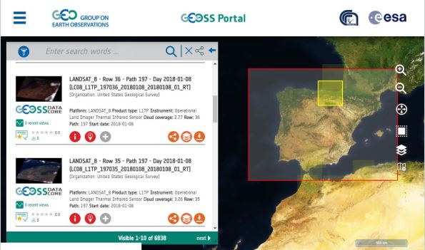
Interface for the Geoportal.
Like other portals, this one allows search terms, but without knowing what is there, the user is left with some confusion knowing what search terms to use. I found myself really wanting a tutorial and a list of data sets I could browse through. Searching is good but the users also need to know what the possibilities are. I am intrigued by the data offerings on the site but had trouble navigating and discovering resources; I frequently encountered this message below and even had trouble drawing the bounding box for my desired search area.

Given the data holdings that are available via this portal, I think it is worth investigating further. The about page on Geoportal lists enhancements to the site that are continually being made, and the mission of the page states that one goal is to make the site intuitive and easy to use. I therefore have high hopes that it will be moving in this direction. Give it a try!
Reflections on the Effective Use of Geospatial Big Data article
Glyn Arthur, in a thought provoking article in GIM International, entitled “Effective Use of Geospatial Big Data“, raises several issues that have been running through the Spatial Reserves blog. The first is to point out that the “heart of any geospatial analysis system is increasingly becoming the server.” Glyn, a GIS professional with over 25 years experience, then dives into one of the chief challenges that this environment brings, namely, to deal with the increasing quantity and variety of data that the world produces. Of particular importance is emerging sensor platforms which must be incorporated into future GIS applications. The second point is the need to embrace, and not avoid, the world of big data and its benefits–but also recognize the challenges it brings. The third point is to carefully consider the true costs of the data server and decision making solution when making a purchasing decision.
Frankly, I found the “don’t beat around the bush” theme of Glyn’s article refreshing. This is evident in such statements as, “for mission-critical systems, purposely designed software is required, tested in the most demanding environments. Try doing it cheaper and you only end up wasting money.” Glyn also points out that the “maps gone digital” attitude “disables.” I think what Glyn means by this is that systems built around the view that GIS is just a digital means of doing what we used to do with paper maps will be unable to meet the needs of organizations in the future (or dare I say, even today). Server systems must move away from the “extract-transform-load” paradigm to meet the high speed and large data demands of users. Indeed, in this blog we have praised those portals that allow for direct streaming into GIS packages from their sites, such as here in Utah and here in North Dakota. The article also digs into the nuts-and-bolts of how to decide on what solution should be purchased–considering support, training, backwards compatibility, and the needs of the user and developer community. Glyn points out something that might not set well with some, but I think is relevant and needs to be grappled with by the GIS community, which is this: A weakness of Open Source software is its sometimes lack of training from people with relevant qualifications and who have a direct relationship with the original coding team, particularly when lives and property are at stake.
Glyn cites some examples from work at Luciad with big data users such as NATO, EUROCONTROL, Oracle, and Engie Ineo. Geospatial server solutions should be able to connect to a multitude of geographic data formats. The solutions must be able to publish data with a few clicks. Their data must be able to be accessed and represented in any coordinate system, especially with temporal and 3D data that includes ground elevation data and moving objects.
Glyn Arthur’s article about effective use of geospatial big data is well-written and thought-provoking.
Contributors
Gallery


Recent Comments