Archive
Accessing Landsat 8 Data through DevelopmentSeed’s Libra Portal
Libra is a very useful browser for open Landsat 8 satellite imagery. You can use it to browse, filter, sort, and download imagery for the entire planet. Libra was developed by DevelopmentSeed, an engineering team solving complex problems with open software and open data, and AstroDigital, a company focused on providing imagery analyzed in real time and streamed to applications via their API.
Libra’s map interface is one of the most straightforward and useful that I’ve ever seen for imagery as evidenced in the screenshot below. On the interface, each circle on the map represents the number of available images at that location. Filters at the top of the map can be used to select a date range, cloud cover percentage, and sun azimuth angle. Bundled downloads are available within one week of the image being taken. Individual bands are available for all 2015 scenes.
Once your download is complete, the site organizers recommend Landsat-util for processing the raw image and getting it ready for publication and analysis. Search results are powered by Landsat 8 Metadata API and images from USGS Earth Explorer. Downloads are provided via Google Earth Engine and Amazon Web Services.
More information and the official announcement about this resource can be found here. Give it a try and let us know what you think.
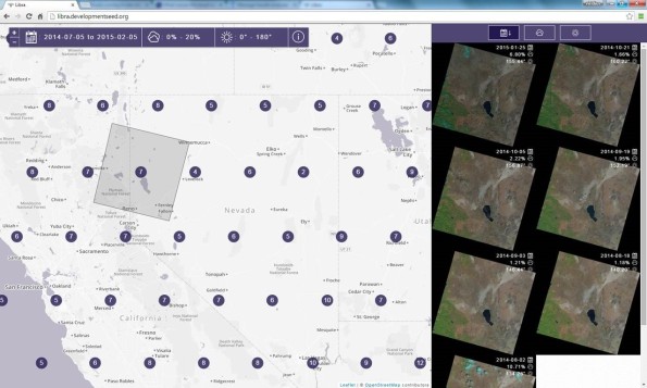
Interface for the Libra Development Seed Landsat Site.
New LandViewer Tool for Quickly Finding and Analyzing Satellite Imagery
The LandViewer tool and data portal quickly and painlessly allows you to browse and access satellite imagery for the planet. The tool, developed by the Earth Observing System Inc.’s Max Polyakov, currently features Landsat 8 and Sentinel 2 imagery with more image sets soon to arrive. Landsat 8 carries two instruments: The Operational Land Imager (OLI) sensor includes refined heritage bands, along with three new bands: a deep blue band for coastal/aerosol studies, a shortwave infrared band for cirrus detection, and a Quality Assessment band. The Thermal Infrared Sensor (TIRS) provides two thermal bands. Sentinel 2 is an Earth observation mission developed by the ESA as part of the Copernicus Programme to perform terrestrial observations in support of services such as forest monitoring, land cover changes detection, and natural disaster management.
Using the LandViewer tool, you can quickly zoom on an interactive web map to your area of interest. You can filter on geography and time, including cloudiness, sun angle, and other parameters. At the time of this writing, 18 filters such as Atmospheric Removal, Panchromatic, NDVI, Thermal Infrared, False Color, and more, are available so that you can obtain the band combinations most suitable to your analysis in the areas of agriculture, geology, or other applications. A very helpful image interpretation screen is available to help you choose the combination that are best for your analysis goals. You can do some contrast stretching in the web tool itself. Then after signing in to the site, you can download the images in GeoTIF for further analysis using your favorite GIS tools.
The tool was also reviewed on the Geoawesomeness web site, and I wholeheartedly agree with their sentiments expressed–this is one of the most useful and fastest satellite image portals I have used. It is useful for research but also, given its ease of use, can even be used effectively to teach concepts of remote sensing. Give it a try and let us know in the comments section what you think.

Landsat scenes with band combinations possible for an area on the southwest side of Costa Rica.
Contributors
Gallery


Recent Comments