Archive
A review of the ArcGIS Hub Gallery
As we have described in this blog, ArcGIS Hub is a set of templates and tools that allow organizations to more easily share their geospatial data holdings and also to engage the community. ArcGIS Hub has emerged over the past few years as a primary way that organizations are sharing geospatial data, and thus is germane to the theme of this blog and our book.
One of the resources that is worth frequently checking is the ArcGIS Hub gallery. The sites in this gallery range from those created by local, regional, and national governments, international agencies, nonprofits, universities, to those created by private companies. At the current time, you can search by these “sectors” but also on Focus Areas: Transportation | Elections | Census 2020 | Financial Transparency | Volunteerism | Open Data.
I advise “frequently checking” because the gallery is actively curated and changes often. But the resources are vast and varied!

–Joseph Kerski
A review of the Arizona AZGeo Data Hub
Recently, the Arizona Geographic Information Council (AGIC) and the Arizona State Land Department (ASLD) launched a new data portal named the AZGeo Data Hub. AZGeo Data Hub is a cloud-based platform built on Esri’s ArcGIS Online functionality. We have written about other platforms based on ArcGIS Hub here and here. Together with the AZGeo Data Hub, these articles show that in a few short years, ArcGIS Hub has been adopted by many organizations as a viable, easy-to-configure way of serving their data and related resources.
The AZGeo Data Hub is designed to provide GIS users with links to online map services, FGDC compliant metadata, and geospatial data downloads. Data on AZGeo includes GIS layers for administrative boundaries, demographics, environmental factors, hydrology, imagery, indices, mining, natural features, transportation, and more. AZGeo is hosted by the Arizona State Land Department and staffed by the Arizona Land Resources Information System (ALRIS).
As we have documented in this blog, sharing data is more than just setting up and maintaining a website. Today’s modern web GIS architecture is very much tied to a vibrant community, of which AZGeo Data Hub is an excellent example. I have been a member of the Arizona GIS community since the mid-1990s and they have long been a wonderful source of technical assistance and are lifelong colleagues. Their schools have been among the USA’s most vibrant in terms of promoting geographic literacy, and their universities and community, technical, and tribal colleges have long been trailblazers in the use of GIS in GIScience, geography, and environmental science programs, and more recently in university libraries, schools of education, and in schools of business.
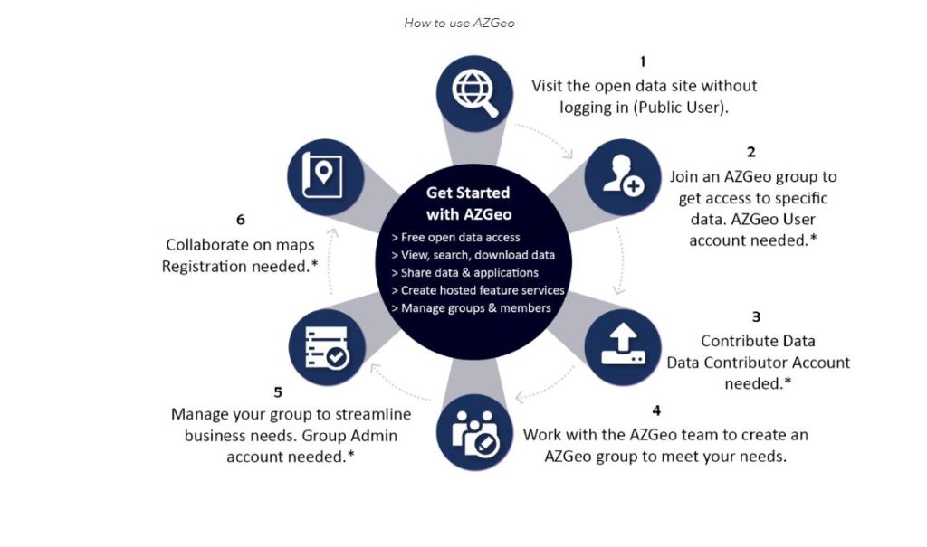
Anyone can view, search and download the data via the AZGeo Data page as a Public User with no login required for access. But in addition, AZGeo utilizes groups to help GIS professionals throughout the state streamline their work processes and share data layers that might be restricted from public access. People can join these groups and then take advantage of the data and applications shared within groups, as well as gain access to ArcGIS Online applications via an AZGeo Hub account. An AZGeo User account is required for this level of access. This is detailed in a helpful graphic, shown below.
My test of the AZGeo Hub’s data page was fruitful. I was able to find a variety of data sets on hydrography, population, land use, and other themes, at a variety of scales. I intend to check back often to see additional data sets that get added over time, and I encourage you to do the same.
Perhaps more important than the data serving is that these Hubs help foster community amongst their users. Many have feedback loops and forums and other means by which the community can interact, strengthening the notion that GIS is not just a set of data and tools, but a system of engagement.
–Joseph Kerski
Finding data via ArcGIS Hubs around the world
As of 2017, over 10,000 open data sites have been published by governments all over the world using ArcGIS Hub technology, as described here. I recently wrote about how to use the ArcGIS Hub open data portal to search for and find geospatial data. This story map is another way to find data, because it lists and provides access to some of these hubs. The story map shows 1,500 sites created back in 2017, so while only a fraction of the total, the map provides an excellent way to browse and find spatial data. I used it recently to easily find transportation spatial data in Victoria, Australia, for example, for the purpose of constructing a GIS lesson around. Update: I do not have the exact figures for 2020, but there must be multiple tens of thousands of Hub sites in existence by now.
Equally important as accessing the data is that the story map raises the important point that the open spatial data movement is more than just about sharing data. As we have written about extensively in this blog, the open spatial data movement is a reflection of the transformation that GIS is bringing in the way government, private, and nonprofit organizations work. This increased collaboration between departments and engagement with citizens is a long-term and oft-difficult effort, but is resulting in increased efficiency, and yes, in data access for all.
Try this story map as a way to discover spatial data, particularly by region, and I think you will find it to be a useful tool. For more information and background on ArcGIS Hub, see this essay by my colleague Andrew Turner.
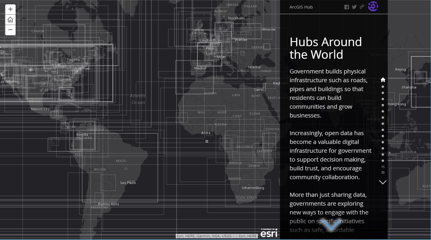
Hubs around the world story map. This map provides a description and access to dozens of data sets served via ArcGIS Hub portal technology.
Finding Data on ArcGIS Hub Open Data Portal
The ArcGIS Hub Open Data Portal has in a short period of time become a very useful means by which geospatial data can be searched, found, and used. I believe that there are two main reasons why: The ArcGIS Hub (1) allows organizations to easily host their own data, and (2) provides an easy to use but powerful set of tools for users to find data. At the time of this writing, nearly 111,000 data sets were linked to the ArcGIS Hub Open Data Portal from nearly 6,000 organizations worldwide.
In keeping with the theme of our book and this blog, pay close attention to each of the data sets listed here that you are interested in using, and make sure you understand the usage restrictions, if any. Not all data sets listed are necessarily “open” for any conceivable use, so again, understand the licensing and usage for your desired data set.
One advantage to using the ArcGIS Hub Open Data Portal from the user’s perspective is its simple layout (Figure 1): The user is presented with a search category box along with a location box; i.e. “near <location x>.” This surprisingly straightforward interface reminds me of how simple I found Google search to be nearly 20 years ago after years of using WebCrawler, AltaVista, and other search engines.
My education outreach team recently used the ArcGIS Hub in an educational context, in our Esri MOOC entitled “Do It Yourself Geo-Apps”. In the MOOC, we had participants leverage open data to build web apps using Washington D.C.’s Vision Zero Safety data to help people learn more about pedestrian and bicyclist safety within the community. Specifically, students in the course searched and found data on commuting in Washington DC, downloaded the data as a shapefile, and uploaded it to their ArcGIS Online account (Figure 2) and began analyzing it.
An alternative workflow becoming rapidly adopted, as we have documented in this blog, rather than download and upload, is to obtain the link for the data as a REST endpoint and add it directly into a working session in ArcGIS Online, from which analysis tools can be run. To do this using the ArcGIS Hub, use the APIs link on the right side after you find your desired data set, with one modification: The GeoService full dataset are often tagged with a query statement. For example, the Michigan hydrography polygons are listed as: https://gisago.mcgi.state.mi.us/arcgis/rest/services/OpenData/hydro/MapServer/17/query?outFields=*&where=1%3D1. To view the data in ArcGIS Online, remove everything after MapServer/, as shown in Figure 3.
Another fascinating feature in that same right-hand zone on the metadata results page is “create story map”, which, as the name implies gets you started right away creating and displaying the data in a story map (Figure 4) – in my case, a map series story map. From this point, you could add additional layers, audio, video, photographs, and narrative to this same story map.
It is understandable with any open portal such as this, with contributions from a wide variety of organizations, that some challenges will exist. From the perspective of the data user, one of those current challenges is finding results to searches on medium sized polygon areas, such as “Colorado” or “Platte River drainage”. However, in the above Washington DC example, even if you did not know the term “Vision Zero”, a search on bicycle safety near Washington DC would provide you the result you are seeking. The data extent for the Washington DC Vision Zero covered the entire North Atlantic Ocean, but that’s no doubt the result of an improperly encoded data point.
There is much more to ArcGIS Hub than this open data portal. ArcGIS Hub includes community engagement tools such as event management, comment management, engagement dashboards, and initiatives. One of the most appealing things about the ArcGIS Hub is that if you have an ArcGIS Online subscription, you can share your own authoritative open data with ArcGIS Hub. By using your existing ArcGIS Online groups to identify data to share, you can set up public-facing websites for people to easily find and download your data in a variety of open formats. Your open datasets are connected to the source and are automatically updated. I highly recommend spending time with the ArcGIS Hub, beginning with the open data portal.

Figure 1. ArcGIS Hub Open Data interface, a very useful tool for finding geospatial data.

Figure 2. Vision Zero safety data for Washington DC from the ArcGIS Hub streamed into ArcGIS Online. 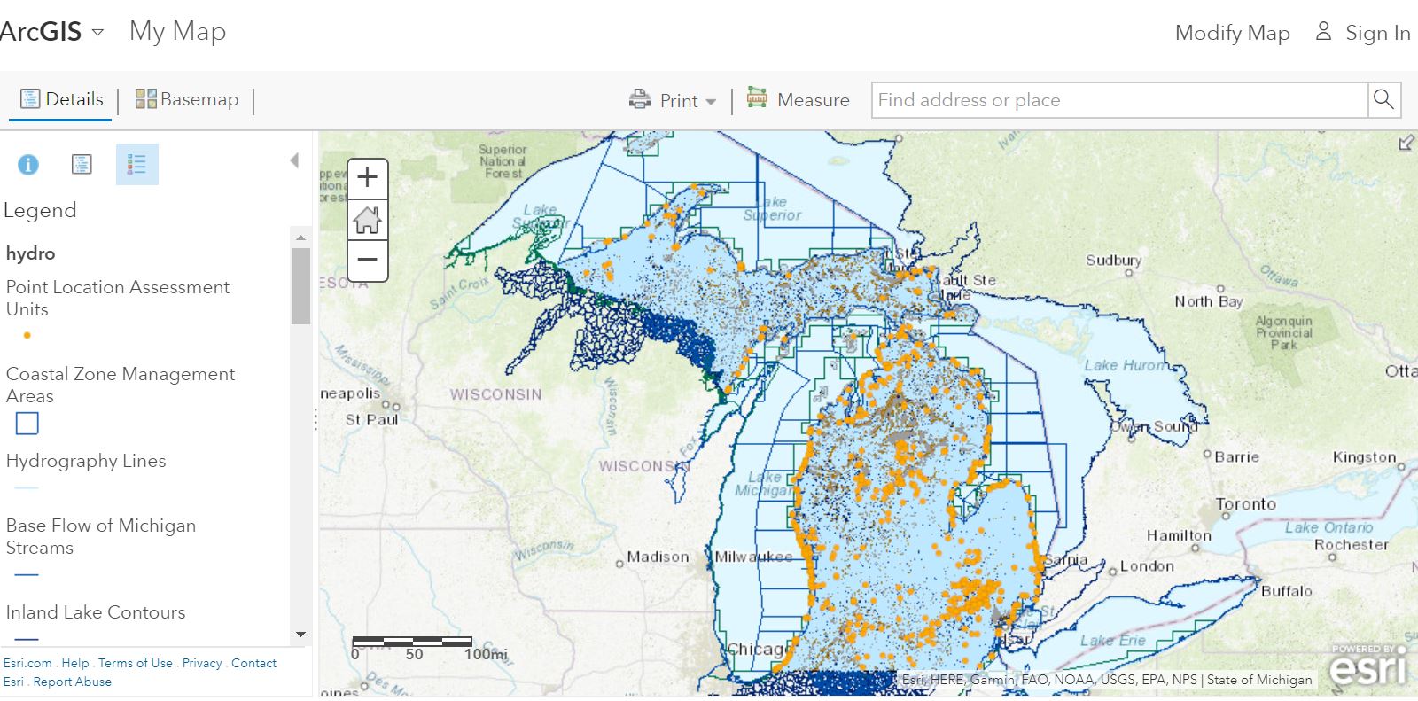
Figure 3. Michigan hydrography data from the ArcGIS Hub streamed into ArcGIS Online.
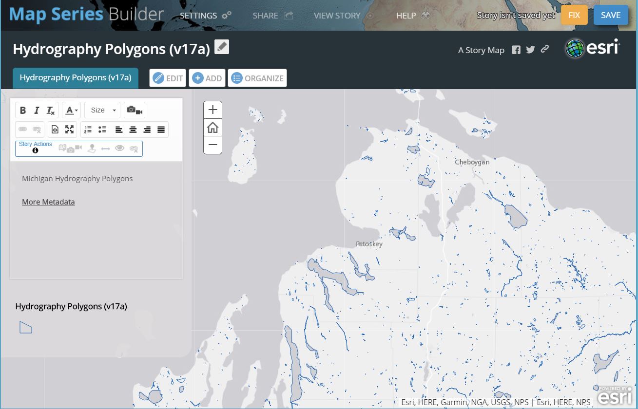
Figure 4. Story map from Michigan hydrography polygons.
Contributors
Gallery


Recent Comments