Archive
Data.census.gov: A new US Census Bureau resource for data
After reviewing the US Census Bureau’s new data site (https://data.census.gov) I find it more intuitive than the standard way of accessing Census data. It was created, according to the site, “based on overwhelming feedback to streamline the way you (the data user) gets data.” Aligned with other data sites that we have reviewed in this blog, the US Census Bureau is drifting away from delivering data through a series of individual tools (such as American FactFinder, OnTheMap, and My Congressional District) to a model where those tools’ capabilities are integrated and served on a single platform, eventually accessible by a single search bar on Census.gov. The US Census Bureau’s vision for data dissemination is to “improve the customer experience so users spend less time searching for data products and more time using them.” That phrase should bring joy to every GIS analyst’s heart.
For those familiar with Census data table numbers, you can search for table “B01001” to view the “Sex by Age” tables. Or, start typing a Table ID and then select the options that appear below the search bar. You can also transpose columns and rows in data tables. You can download data tables in .CSV format and download multiple years in one ZIP file. This site is a work in progress. Don’t expect miracles and everything in the immense Census archive to suddenly become easy to access. All of my searches resulted in hundreds or even thousands of hits, for example, a search for “census tract boundaries orange county california” netted over 1,000 entries, most of which had nothing to do with my search. Thus, (1) the site still needs work but also (2) I need to spend more time with it. You may need to bail out to the tried-and-true FTP site for some data. To their credit, creating an easy-to-use resources for a data archive for the US Census Bureau has got to be a challenge. After working over 4 years as a Census Bureau geographer, helping create the TIGER system, I have great respect for the agency.
While the site represents quite a bit of information to deal with, the release notes (https://data.census.gov/assets/releasenotes/faqs-release-notes.pdf) are helpful. The section on known limitations, part of the release notes, are particularly useful.
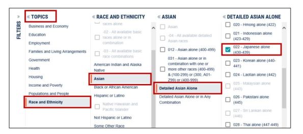
Conducting a search with the US Census Bureau’s new data resource.
—Joseph Kerski
Copernicus Earth Observation Programme – Data and Information Access Services (DIAS)
To facilitate access to the European Space Agency’s (ESA) Copernicus earth observation data (Sentinel satellites), the European Commission has funded five cloud-based platforms, known as the Data and Information Access Services (DIAS), to provide users with easy access to data from the various satellite missions. The data are available on the platforms, subject to account registration, as both open data and on a pay-per-use basis.
The following examples of data search and download options were taken from the WEkEO data service. The other data hosting services include ONDA, numdi, sobloo and CREODIAS.


The raw data are available as NetCDF (.nc) files on the WEkEO site, an example of which is shown here using the Panoply data viewer.

There are various tools available to convert NetCDF files to more GIS friendly formats such as the Marine Geospatial Ecology Tools, a free add-on for ArcGIS that converts NetCDF to ASCII and ArcGrid formats.
The Top 12 Most Useful Landsat Image Sites
Recently, I wrote an essay about the sites that are, in my judgment, the top 10 in terms of containing useful geospatial data. Now, I would like to describe what I consider to be the top sites for Landsat satellite imagery in terms of content and ease of use. Let’s limit it to the Top 12. Why might such a list be helpful? First, there is no “one single site” to obtain Landsat data, and second, the sites are in continual flux, with some such as the Global Land Cover Facility disappearing and some having recently been created. As with any consideration of data portals, make sure you have done a careful assessment of your data needs–band combinations, resolutions, formats, streamed services vs. downloaded files, dates, how many files you need, and so on, to guide you before you start searching.
(1) The DevelopmentSeed’s Libra Portal. I recently used this resource to include in the update (to ArcGIS Pro) for the Brazil land use change lesson that we host on the Spatial Reserves set of 10 hands-on exercises. We wrote about the Libra portal here, and it remains in my judgment a no-nonsense resource that is easy to use with a wealth of options and data.
(2) The EOS Data Analytics Landviewer, as we described here, is very useful and user friendly. The EOS staff also wrote this helpful review of imagery sites. Like the DevelopmentSeed portal, I find its user interface to be very straightforward. The Landviewer includes Sentinel-2 and other imagery, as well.
(3) Esri’s ArcGIS Living Atlas of the World has made amazing strides in content and usability since we first wrote about it here. Most of Esri’s ArcGIS Living Atlas data is provided as streaming services instead of download, but for an increasing number of workflows, this is actually perfect. The Living Atlas has in a few short years become probably the largest collection of spatial data on the planet, and so I recommend keeping it in mind not just for satellite imagery, but vector data as well, some of which can be downloaded, and all of it can be streamed. Plus, you can contribute your organization’s data to the Living Atlas. On a related note, be sure to check ArcGIS Online for imagery as well, the web GIS platform that Esri’s ArcGIS Living Atlas is based on.
(4) The Esri Landsat Thematic Bands Web Mapping Application. As we described in this post, through this application, you can access a variety of up-to-date and historical images in various band combinations, and save specific configurations and locations to share with others.
(5) The USGS Earth Explorer. While the Earth Explorer is in my view in need of improvement from the user’s perspective, it is functional and does contain a wealth of data, and sometimes is the best source for specific image sets.
(6) The USGS Landsat Look Viewer. I prefer the Landsat Look viewer’s interface over the Earth Explorer, as I described here.
(7) The USGS GloVIS viewer. I also prefer this interface over Earth Explorer. GloVIS dates back to 2001 and was redesigned in 2017.
(8) Landsat 8 archive on Amazon AWS. As we described here, this has emerged as an amazing archive of data. The user, as one might expect, is faced with a list of files rather than a fancy User Interface, but sometimes accessing specific files is exactly what one needs.
(9) Landsat archive in Google Cloud. Like the AWS experience, the UI is spartan but its data sets are vast, which is what one would expect from Google.
(10) The FAO GeoNetwork. This site focuses on vector data sets, but its raster holdings include many useful Landsat mosaics for specific geographic areas such as countries.
(11) Remote Pixel. This is incredibly easy to use and blazing fast to zoom, pan, and query, and largely the work of a single individual. It is my hope that if its developer does not maintain it in the future, that someone else will, because it is so marvelous. Fortunately, the developer shows others how to host something like this themselves.
(12) The Copernicus Open Data Access Hub, as its name implies, focuses on Sentinel data, but if you are interested in Landsat imagery, you probably are interested in other imagery as well.
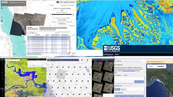 A few of the image portals described in this article. We look forward to your feedback!
–Joseph Kerski
Contributors
Gallery


Recent Comments