Archive
New US Census Bureau Address Count Listing Files Released
I’ve worked with and have had great respect for Geographer Jim Castagneri, who is with the US Census Bureau, for many years now. When I asked him to write for the Spatial Reserves data blog, about some of his favorite new data sets and services, I was thrilled that he agreed. Here, Jim shares an important geographic product release that I believe will be of interest to data analysts and GIS users. I’ve tested this resource myself and agree that it is extremely useful. —Joseph Kerski
**************************************************************************
The lack of detailed population counts available in the intercensal period has troubled data users since the introduction of the modern census. Aside from local efforts to track and record housing and population change, the federal government now has a new dataset to assist in this effort.
Called the Address Count Listing Files, these data represent the latest available count of housing units by census block updated bi-annually. These files are created for all 50 States, Washington D.C., Puerto Rico, and U.S. Island Areas. The latest data release was in January of 2023. More information on these files and how to download them can be found here:
https://www.census.gov/geographies/reference-files/2023/geo/addcountlisting.html
These files are relevant for several reasons. First, they represent the first-time the Census Bureau has released updated, block-level housing counts between decennial censuses. Second, the housing counts are actual counts, not estimates, and they are not affected by the Bureau’s new Differential Privacy non-disclosure effort.
Paired with the annually revised TIGER Partnership Shapefiles, local planners and regional emergency responders can now derive relatively accurate, detailed population figures without a need to conduct aerial interpolation or the more rigorous dasymetric modeling with tangentially related datasets. By considering local housing occupancy rates and persons-per-household figures, one can derive a fairly accurate population count at the block level independent from the decennial census count.
The above site also contains a very helpful viewer app based on ArcGIS technology (shown below).

Possible implications to census data from Disclosure Avoidance System
The new Disclosure Avoidance System (DAS) being used for the 2020 US Census counts could have implications for all users of census data. First, from the National Conference of State Legislatures, see this informative overview: https://www.ncsl.org/research/redistricting/differential-privacy-for-census-data-explained.aspx. To dig deeper, see this US Census Bureau story map and this dashboard as well as this NY Times article.
From a GIS perspective, here is an essay about spatial analysis and differential privacy from Lauren Scott Griffin: https://storymaps.arcgis.com/stories/ec6d9711a3364d3db5c18fc9061e312f
And for a map-based set of examples, compare places on this Esri dashboard: https://arcgis-content.maps.arcgis.com/apps/opsdashboard/index.html#/04451f90e7b049f39aa6647a41b986ac
Why should you care? This is all extremely relevant to the central theme of this blog–be critical of the data. Know what methods are used to gather the data, and the models or algorithms employed to generate the results, and be a more informed data consumer.
–Joseph Kerski
Data.census.gov: A new US Census Bureau resource for data
After reviewing the US Census Bureau’s new data site (https://data.census.gov) I find it more intuitive than the standard way of accessing Census data. It was created, according to the site, “based on overwhelming feedback to streamline the way you (the data user) gets data.” Aligned with other data sites that we have reviewed in this blog, the US Census Bureau is drifting away from delivering data through a series of individual tools (such as American FactFinder, OnTheMap, and My Congressional District) to a model where those tools’ capabilities are integrated and served on a single platform, eventually accessible by a single search bar on Census.gov. The US Census Bureau’s vision for data dissemination is to “improve the customer experience so users spend less time searching for data products and more time using them.” That phrase should bring joy to every GIS analyst’s heart.
For those familiar with Census data table numbers, you can search for table “B01001” to view the “Sex by Age” tables. Or, start typing a Table ID and then select the options that appear below the search bar. You can also transpose columns and rows in data tables. You can download data tables in .CSV format and download multiple years in one ZIP file. This site is a work in progress. Don’t expect miracles and everything in the immense Census archive to suddenly become easy to access. All of my searches resulted in hundreds or even thousands of hits, for example, a search for “census tract boundaries orange county california” netted over 1,000 entries, most of which had nothing to do with my search. Thus, (1) the site still needs work but also (2) I need to spend more time with it. You may need to bail out to the tried-and-true FTP site for some data. To their credit, creating an easy-to-use resources for a data archive for the US Census Bureau has got to be a challenge. After working over 4 years as a Census Bureau geographer, helping create the TIGER system, I have great respect for the agency.
While the site represents quite a bit of information to deal with, the release notes (https://data.census.gov/assets/releasenotes/faqs-release-notes.pdf) are helpful. The section on known limitations, part of the release notes, are particularly useful.
Conducting a search with the US Census Bureau’s new data resource.
—Joseph Kerski
Reviewing the US City Open Data Census Portal of Geospatial Content
The US City Open Data Census portal is “an ongoing, crowdsourced measure of the current state of access to a selected group of datasets in municipalities across the United States.” The portal represents another example of a trend we have been noting in this blog for quite some time, a catalog that is a combination of crowdsourced and created by the authors. In this case, “Any community member can contribute an assessment of these datasets in their municipality at any time. Census content will be peer-reviewed periodically by a volunteer team of Census librarians. [..] The US City Open Data Census began as a partnership between Code for America, the Sunlight Foundation, and Open Knowledge International. It is maintained by Sunlight Foundation staff members, with technical support from Open Knowledge, local outreach by Code for America brigades, advising from the Open Government Data working group, and contributions from many members of the wider community.”
In the case of this site, don’t think “Census” in terms of demographic data gathered by statistical agencies, but rather, “census” as a catalog of geospatial data for municipalities. The 18 themes currently cataloged for urban areas include crime, parcels, zoning, and others, but also those that are of interest but may be outside typically considered and sometimes a-spatial categories, such as lobbyist activity, web analytics, and spending. At this time, the site’s focus is on the U.S. only. Cities are ranked by the variety and amount of data in the catalog, and at the time of this writing, Las Vegas achieved top score. Testing this site, I was able to find quite a volume of data, in many formats that I could use, and in some formats I was not familiar with but was able to find out more about them. If the data set I needed was not available, which occurred on more than one occasion, the site tells me who to contact.
If a data user wanted to obtain a set of data to compare across cities, this data set would save that data user quite a bit of time scouring each city’s GIS data site. Therefore, even though the site’s ambitious list of themes are empty for many cities, and in many ways this project is just getting started, this resource may be valuable for your needs. And in part because it is crowdsourced and curated, it could become even more valuable in the future. Time will tell if it persists. And, like any resource, be critical of its sources and use it if you deem that it will meet your needs.
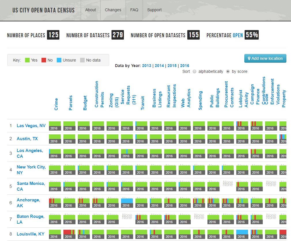
Visualizing data cataloged by the US City Open Data Census portal, ranked by “score”, with a lower number indicating that a greater volume and wider variety of data is available for that city.
National and Subnational Population Data and Maps from US AID and US Census Bureau
As readers of this blog and our book are aware, when a geodata portal is confusing or inadequate, we are not afraid to say so. And conversely, when a resource comes along that contains a wealth of content and is actually intuitive to use at the same time, we share that as well. An example of a new, useful, and intuitive resource comes from the Demographic and Health Surveys of the US AID program and the US Census Bureau. The site provides detailed demographic data primarily for countries that receive assistance via the President’s Emergency Plan for AIDS Relief (PEPFAR). The data are available for single countries and also multiple countries through a data package, all of which the user chooses and customizes. Through the site, the US Census Bureau has added to and updated the online collection of subnational population data linked to maps.
To access the maps and data, begin at the main website for the project, select Data, select countries, select indicators (variables), select the format (shapefile or geodatabase), and indicate whether you want to download it now in a browser or receive an email when the package is ready. You can choose up to 25 variables at a time to be included in the package. I tested it and it worked marvelously. Also, in the near future, the US Census Bureau will release a seamless global map containing population estimates for tens of thousands of subnational administrative areas globally. Wouldn’t it be grand if all sites were this simple to use?

The Spatial Data Repository provides health and demographic data from The Demographic and Health Surveys Program and the U.S. Census Bureau.
Open Data UK Census Pack released
GeoLytix, a UK-based data provider and consultancy company, have recently released a UK Census Data pack free of charge. The data pack has been made available under the same terms as the source data collected by the Office of National Statistics (ONS), The National Records of Scotland (NRS) and the Northern Ireland Statistics and Research Agency (NIRSA) and is released under the Open Government License (OGL). The data are available at Output Area level, the lowest geographical level at which census estimates are provided. Each output area is ‘... designed to be socially homogeneous and spatially compact and contiguous‘. Output areas are also limited by population and household: at least 40 households/100 individuals in England, Wales and Northern Ireland, and 20 households/50 individuals in Scotland.
The data pack contains 197 variables covering 21 themes: 15 themes relating to people (age, status, gender, travel to work and so on) and 6 themes relating to households (including type, size, access to cars).

Output Areas for Merseyside (NW England)
Contributors
Gallery


Recent Comments