About the book
Joseph Kerski and Jill Clark co-authored the book The GIS Guide to Public Domain Data.
The book is available from Esri Press and from Amazon.
The book aims to help GIS users, instructors and others develop their skills in finding, using, and applying spatial data to solve problems. It also highlights some of the issues GIS practitioners are likely to encounter working with spatial data, including format, pricing, copyright, cloud computing and more.
The book also provides context for the development of the numerous data portals we see today in terms of the organizations that collect and provide access to data, and the policies that govern data use. Each chapter in this book discusses the major issues associated with public domain spatial data by presenting both sides of the debate, helping you appreciate the complexity of these issues and their relevance in your everyday work with GIS. This information will help users in all areas of the GIS community become critical users of data – mindful of provenance, quality, and appropriate use.
Each chapter of the book is viewable in this gallery.
The book Esri Press page containing resources that serve to supplement each chapter.
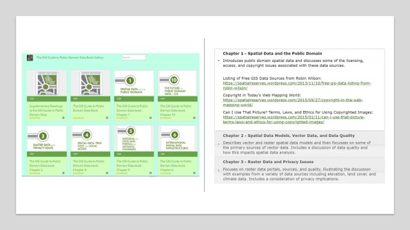
The book’s chapters in the ArcGIS Online gallery (left) and the Esri Press book resources page with supplementary readings (right).
Leave a comment
Contributors
Gallery


Dear Joseph,
Received your new book yesterday and read the first chapter last night. I want to congratulate you on producing a truly wonderful book for the GIS community. I am very impressed with the writing, organization and the telling of the story. This book talks to me and has already answered many of my questions about information and spatial data.
Thank you very much for creating this remarkable book,
Martin
Martin J. Spann
Teaching Assistant Professor
EPICS Program
Colorado School of Mines
Golden, Colorado USA
+1 303 273 3810
Dear Joseph,
I had the distinct pleasure of receiving a desk copy of this text book a few months back. It is certainly a must read for anyone looking to work with satellite or census data. At my stage of a GIS career I found the book very useful and educational. I would recommend the book for any GIS professional who has been in the game for a while but may not have considered data use issues explicitly. Also, any person looking to find some great open data sources should consider this guide as a definitive source!
Congratulations on this great book!
Kytt MacManus
Geographic Information Specialist
Adjunct Professor of GIS
Columbia University CIESIN
Joseph and Jill –
Kudos for creating such a thorough, practical, and provocative discussion about spatial data! Nice to have a single source that covers everything from data models and metadata, to the challenges of privacy, ownership, and appropriate use. Particularly enjoyed the discussion around infrastructure, data portals, and the emerging challenges and opportunities created as data consumers increasingly function as data providers. Felt like I was on a guided tour with a master data docent. Thanks!
doug geverdt
u.s. census bureau, governments division
education demographic and geographic estimates project
washington dc
Thanks Doug, we’re glad you found it useful.
Jill Clark
Dr Bruce Ralston of the University of Tennessee Knoxville has published his review of the book on http://www.amazon.com/The-Guide-Public-Domain-Data/dp/1589482441 – the book’s Amazon site. Thank you Dr Ralston! And coming from someone I highly respect, and an author of your own GIS data book, it is a huge honor.
Since the book was published, there has been a rapid increase in concerns surrounding: How do I find data? How do I know if it is any good? What about the privacy of my data? How can I crowdsource my next data gathering project or use crowdsourced data that others have created? Should I download data or stream it from the cloud? Are any of the data sets I am using copyrighted, and if so, how might that affect me? Hence, the book is more relevant than ever before. We would be very interested to hear about your use of the book in teaching as a GIS instructor or in your job as a GIS professional.