Archive
Download Arctic area digital elevation data from ArcticDEM
Here we are at the winter solstice in the Northern Hemisphere and it seems appropriate to discuss polar data. ArcticDEM is an NGA (National Geospatial Intelligence Agency) – NSF (National Science Foundation) public-private initiative to produce a high-resolution (2 meter), high quality, digital surface model (DSM) of the Arctic using optical stereo imagery, high-performance computing, and open source photogrammetry software. The majority of ArcticDEM data was generated from the panchromatic bands of the WorldView-1, WorldView-2, and WorldView-3 satellites. A small percentage of data was also generated from the GeoEye-1 satellite sensor. The resource covers all land north of 60 degrees north latitude. Yes! Not only Alaska, but Scandinavia, Russia, Canada and Iceland. For more information, see this page. For a web mapping application the Arctic DEM Explorer from Esri, see this page, and for the bare-bones but useful file index for fast downloading, see this page.
In my opinion, the most useful site about Arctic DEM for downloading the data is this web mapping application, the ArcticDEM index and data download. This application allows a user to select specific index tiles of digital elevation model data. The tiles reveal information about the DEM tile and a download web URL. Each cell is about 2GB, with over 18 TB on the entire site. Truly a treasure trove of data! For selecting multiple indices, use the ‘Query’ tool to draw an area and return information on intersecting DEM tile indices. You can export these results for your reference which also include the download web URLs.
Click on any location for attribute information. Find the “fileurl” attribute, click on More info, and then you will be able to download the 2 meter elevation data for that location. The query widget allows for the retrieval of information from source data by executing an intersect query either against 2m DEM strips or 2M DEM mosaics. The resource also includes a swipe tool where you can compare the content of two different layers on the map, such as the index layer and the hillshade.
The best news about this resource, and consistent with our continued mantra about GIS as a SaaS, may be that the site allows for the data to be examined as an ArcGIS Online item and also as an image service via a URL.
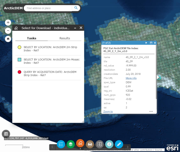
Interface of the Arctic DEM Index and Data Download resource.
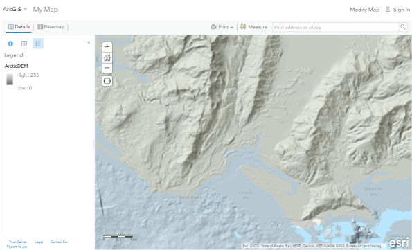
The Arctic DEM data streamed and viewed in ArcGIS Online.
I look forward to hearing your reactions to this resource.
–Joseph Kerski
New Alaska Elevation Data Now Available
Exciting news from the Arctic! Version 2 of the Arctic DEM has been released. Topographic elevation of the Arctic can now be viewed and analyzed like never before. This release extends the detailed 2 meter Alaska elevation data with additional 2m data for Novaya Zemlya and Franz Josef Land, as well as preliminary 8 meter data for the entire Arctic. Additional detailed 2 meter elevation data will be released in quarterly installments over 2017 until the arctic data is complete. This is the result of a partnership between Esri, the National Geospatial Intelligence Agency, the National Science Foundation, and the Polar Geospatial Center at the University of Minnesota.
In September 2016, the US at the White House hosted an Arctic Ministerial meeting, with over 20 countries represented, where this data was showcased and new commitments on data provisions were sought. The goal of the meeting and the new data is to help people better understand, adapt to, and address the changing conditions in the Arctic.
The four key themes include:
- Understanding Arctic-Science Challenges and their Regional and Global Implications.
- Strengthening and Integrating Arctic Observations and Data Sharing.
- Applying Expanded Scientific Understanding of the Arctic to Build Regional Resilience and Shape Global Responses.
- Using Arctic Science as a Vehicle for Science, Technology, Engineering, and Math (STEM) Education and Citizen Empowerment.
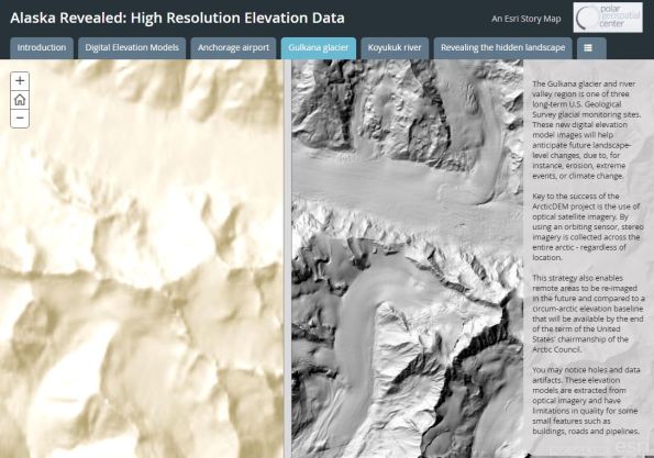
To access the data, start with the NGA Arctic Support story map here and spend time on the ‘Arctic Digital Elevation Model (ArcticDEM) ’ tab. The embedded apps provide interactive access to the elevation. The data is described in an article here from Medium.com and an article from National Geographic here. This story map illustrates the visualizations that can be generated with the click of the mouse for any user selected area, and a swipe story map explains the background on Digital Elevation Models and compares the new elevation data to the older elevation data by providing the ability to swipe between the maps. The DEMs have been computed from high resolution stereo Digital Globe satellite imagery.
The DEM Explorer is a web app that allows the data user to zoom to any area and review different visualizations such as hillshade, slope, aspect, contours. As the data is temporal in many areas, users can see how the data is changing over time and summarize elevation change for a selected areas. The Change Viewer is a simpler app that allows a user to click a point and graphically view the historical elevation of that location. Access to these services is also available in a wide range of applications through the Arctic DEM Group in ArcGIS Online. Most of the apps use the polar projections to reduce distortions which would become severe in generic mapping applications. Finally, a video tour of the story map highlights many of the above products and services.
The actual data are available–not just press releases, and the data will be of great benefit for anyone doing research in the Arctic, as the map below should make very clear.
Alaska DEMs showing the heretofore available data (left) and the new data (right).
USGS National Elevation Dataset (NED) moving to Lidar-based elevation model
The USGS National Elevation Dataset (NED) is transitioning to a Lidar-based elevation model. This transition is part of the 3D Elevation Program (3DEP) initiative, whose goal is to systematically collect enhanced elevation data in the form of Lidar data over the conterminous United States, Hawaii, and the U.S. territories, with data acquired over an 8-year period. Interferometric synthetic aperture radar (IFSAR) data will be collected over Alaska, where cloud cover and remote locations preclude the use of Lidar over much of the state (yes, physical geography still matters!).
This initiative was born in response to a study funded by the USGS named “The National Enhanced Elevation Assessment.” The study documented business uses for elevation needs across 34 federal agencies, agencies from all 50 States, selected local government and Tribal offices, and private and not-for profit organizations. Each need was characterized by the following:
- Data accuracy.
- A refresh cycle for the data.
- Coverage for geographic areas of interest.
Conservative annual benefits for flood risk management alone are $295 million; for infrastructure and construction management, $206 million; and for natural resources conservation, $159 million. Results are detailed in the Dewberry report on the National Enhanced Elevation Assessment, which details costs and benefits, how the data will be collected, standards and specifications, and organizations involved in the effort. An additional report details how the data could help in terms of taking action for climate change.
How will this affect us in the geospatial data community? The NED activities and website will continue until a full transition to 3DEP is completed. 3DEP planning and research is underway at the USGS to transition to a unified service that will provide both gridded bare earth data products and point cloud data, along with capabilities to produce other derived elevation surfaces and products from 3D data. When the data does appear, data users should notice the difference in resolution and quality. In our book, we detailed the rise of Lidar data, and since its publication, these data sets have greatly expanded in quality and availability.

High-resolution lidar image of Mount St. Helens, Washington.
High-resolution SRTM elevation data to be released globally

Comparing SRTM data spatial resolution: 90 meters on the left, 30 meters on the right.
High-resolution elevation data from the Shuttle Radar Topography Mission-Level 2 (SRTM-2), previously only available for the USA, will be made publicly available over the next 12 months, the White House announced recently at the United Nations Heads of State Climate Summit. The first elevation data set to be released will be over the African continent and is available on the United States Geological Survey’s Earth Explorer website, by choosing the “SRTM 1 Arc-Second Global” data set, with future regions to be released within the coming year.
“I look forward to the broader impact that the release will have on the global scientific and capacity building community,” said National Geospatial-Intelligence Agency (NGA) Director Letitia Long. Until now, SRTM data was only publicly available at a lower 90-meter resolution (see above image). The newly-released global 30-meter SRTM-2 dataset will be used worldwide to improve environmental monitoring, climate change research including sea-level rise impact assessments, and local decision support, the White House said.
The SRTM mission began in 2000 as a venture between NASA and NGA that used a modified radar system on board the Space Shuttle Endeavour to acquire elevation data for over 80% of the Earth’s land mass. The Department of Defense and intelligence community continues to use this topographic data for multiple applications – from developing navigation tools and supporting military operations, to geological and environmental purposes. In August 2014, Long authorized the removal of the Limited Distribution caveat from the SRTM-2 dataset, making it available to the public on a phased-release schedule. The 30-meter topographic dataset was then sent to USGS for public distribution.
When I heard Shuttle pilot Dom Gorie speak about his work with the SRTM at a GIS conference about 10 years ago, it was one of the most memorable keynote addresses I have ever heard. I look forward to investigating this new data set and the delivery mechanism. Keep an eye on this blog for further updates.
Exploring the US Interagency Elevation Inventory
The US Interagency Elevation Inventory offers the ability to display and download topographic and bathymetric data for the USA. A collaborative effort from NOAA, USGS, and FEMA, the resource contains DEM, Lidar, IFSAR, hydrographic surveys, and multibeam and Lidar bathymetric data.
The site hosts have done a decent job populating the metadata, including vertical accuracy, point spacing, and data collection, and the inventory contains a good variety of data types and formats. To get started, visit the link above and then “Launch the Viewer.”
In my case illustrated below, I was searching for Lidar data for the area around Meteor Crater, Arizona. After finding it, I was then placed on Open Topography’s site at SDSC for the whole country, requiring me to select my desired area in Arizona again on this new map. Oddities like this are common to federal data portals, as we document in our book. Despite this, the US Interagency Elevation Inventory is a useful resource for elevation data.

Downloading elevation data from Elevation Inventory.
How might you be able to use this resource? We look forward to hearing your reflections.
Contributors
Gallery


Recent Comments