The Montana Digital Atlas
We wrote extensive reviews of local, regional, state, provincial, national, and international government data portals in our book and from time to time do so in this blog. One of the finest state geospatial data portals in our judgment is the Montana Digital Atlas.
We have been critical here and in our book about data portals that were obviously set up simply to satisfy some organizational mandate without regard to those who will actually use the data portal. I have spent time with the MAGIP (Montana Association of Geographic Information Professionals) community, and most recently was honored to give the keynote at their annual conference. I am happy to report that they have built their data portal with the end user in mind. What’s more, the Montana State Library has been a leader in the GIS community there for years, and I have found that when library information professionals are involved–people who really understand data–their resources will be extensive, the metadata will be rich, and the services are actually going to work.
The Digital Atlas features geographic databases, aerial photos, and topographic maps of lands in Montana. The functions begin with an interactive map, where you can select base maps, thematic map layers, and tabular data from which you can draw on the screen, generate reports from in XLS and CSV formats, and download in various GIS formats. The site features functionality that I wish all data portals had, such as the ability to move popup boxes to locations most convenient for you, choices on datums and projections for your data, the ability to clip data to specific geographic areas, and the ability to search the state library catalogs for articles, books, and other resources for the area you are investigating. You can even copy the map link to get a web link to the current map that you have created on the site. Furthermore, you can load some of the layers directly from the Montana State Library to ArcGIS Online, via the services in the ‘MSDI_Framework’ and ‘MSL’ folders, on https://gisservicemt.gov/arcgis/rest/services/MSDI_Framework and https://gisservicemt.gov/arcgis/rest/services/MSL.
Lastly, the portal managers graciously say to contact them at MSLDA @ mt.gov if you experience difficulty with the application, if you see a problem with any of the data, or even–and this is wonderful–to suggest additional map layers.
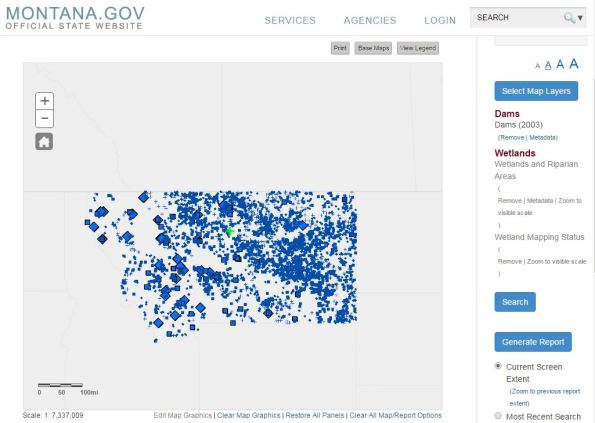
The Montana Digital Atlas. I have selected dams, wetlands, and riparian zones. At this point, I can generate reports, download the data, or clip and otherwise modify my data search.
Contributors
Gallery


Recent Comments