Data Quality and Intentional Offsets on Interactive Web Maps
Modern web maps and the cloud-based GIS tools and services upon which they are built continue to improve in richness of content and in data quality. But as we have focused on many times in this blog and in our book, maps are representations of reality. They are extremely useful representations, to be sure, particularly so in the cloud, but still are representations. These representations are dependent upon the data sources, accuracy standards, map projections, completeness, processing and rendering procedures used, regulations and policies in place, and much more. A case in point are offsets between street data and the satellite image data that I noticed in mid-2017 in Chengdu in south-central China. The streets are about 369 meters southeast of where they appear on the satellite image (below):

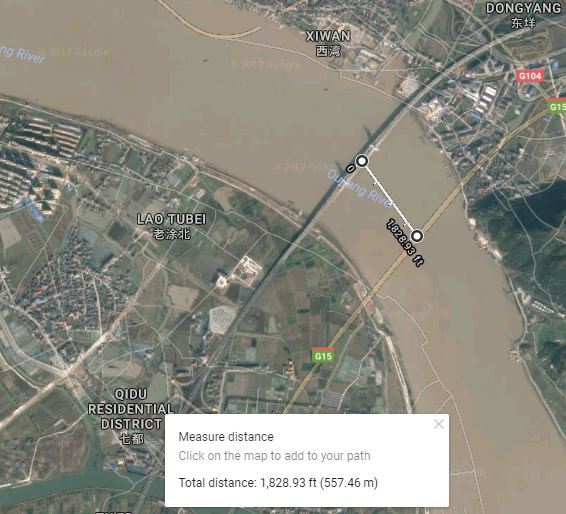
Puzzled, I panned the map to other locations in China. The offsets varied, but they appeared everywhere in the country; for example, note the offset of 557 meters where a highway crosses the river at Dongyang, again to the southeast:
As of this writing, the offset appears in the same cardinal direction and only in China; indeed; After examining border towns with North Korea, Vietnam, and other countries, the offset appears to stop along those borders. No offsets exist in Hong Kong nor in Macao. Yahoo Maps Bing Maps both show the same types of offsets in China (Bing maps example, below):

MapQuest, which uses an OpenStreetMap base, showed no offset. I then tested ArcGIS Online with a satellite image base and the OpenStreetMap base, and there was no offset there, either (below). This offset is a datum issue related to national security that is documented in this Wikipedia article. The same data restriction issues that we discuss in our book and in our blog touch on other aspects of geospatial data, such as fines for unauthorized surveys, lack of geotagging information on many cameras when the GPS chip detects a location within China, and seeming unlawfulness of crowdsourced mapping efforts such as OpenStreetMap.
But furthermore, as we have noted, the satellite images are processed tiled and data sets, and like other data sets, they need to be critically scrutinized as well. They should not be considered “reality” despite their appearance of being the “actual” Earth’s surface. They too contain error, may have been taken on different dates or seasons, may be reprojected on a different datum, and other data quality aspects need to be considered.

Another difference between these maps is the wide variation in the amount of detail in terms of the streets data in China. The OpenStreetMap was the most complete; the other web mapping platforms offered a varying level of detail; some of which were seriously lacking, surprisingly especially in the year 2017, in almost every type of street except major freeways. The streets content was much more complete in other countries.
It all comes back to identifying your end goals in using any sort of GIS or mapping package. Being critical of the data can and should be part of the decision making process that you use and the choice of tools and maps to use. By the time you read this, the image offset problem could have been resolved. Great! But are there now new issues of concern? Data sources, methods, and quality vary considerably among different countries. Furthermore, the tools and data change frequently, along with the processing methods, and being critical of the data is not just something to practice one time, but rather, fundamental to everyday work with GIS.
Leave a comment
Contributors
Gallery


While preparing my holiday to China 2 years ago (train and roadtrips) I came accross the same problems!
Indeed, Peter! Good point … these things affect everyday life – not just GIS work!
–Joseph
I just noticed this offset in Google Maps after returning from Shanghai, June 2019. A frustrating mess when trying to view where we walked and caught the subway. Thankfully I took enough pictures looking down from the 26th floor of our hotel and that helped me locate myself better than any address! Nice article Joseph!
Thanks Lisa and glad you were able to travel to China! But yes, be critical of mapped data, most definitely! –Joseph K
Also Lisa what I would like to confirm from someone who has taken a coordinate there, that NEITHER the vectors nor the image in China are in the correct position – they are BOTH offset somewhat. But I need to travel there to confirm or take a position from someone who has gathered one there on the ground. –Joseph K