Archive
Top 7 Satellite Imagery Sources
My colleagues at EOS.com recently wrote a summary of what they consider to be the top 7 satellite imagery sources: https://eos.com/blog/7-top-free-satellite-imagery-sources-in-2019/.
These include sources that we have reviewed on this Spatial Reserves blog, here: https://spatialreserves.wordpress.com/2019/02/18/the-top-10-most-useful-geospatial-data-portals-revisited/ as well as the top Landsat sites that we reviewed, here: https://spatialreserves.wordpress.com/2019/08/04/the-top-10-landsat-image-sites/, but it also includes a few we have not reviewed, such as EOS’ own Landviewer.
It is good to see reviewed collections such as these that have an aim to make life a bit easier for us as data consumers and analysts.
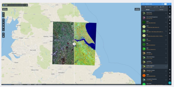
Landviewer data portal, from EOS.
–Joseph Kerski
The Top 10 Most Useful Geospatial Data Portals, Revisited
We have been writing this geospatial data column for 7 years now, beginning when our book The GIS Guide to Public Domain Data, was published. Over those years, in addition to keeping issues such as data quality, copyright, privacy, and fee vs. free at the forefront of the conversation, we have tested and reviewed many geospatial data portals. Some of these portals promise more than they deliver, some have been frustrating, but many have been extremely valuable in GIS work. Back in 2017 we listed 10 of those that we have found most useful, rich with content, easy to use, and with metadata that is available and understandable. A few are no longer functioning, and a few have emerged that merit inclusion in the top 10 list. In creating such a list, we realize that “most useful” really depends on the application that one is using GIS for, but the list below should be useful for GIS users across many disciplines. Some allow for data to be streamed from web servers into your GIS software, and all allow data to be downloaded.
- The Open Data portal based on ArcGIS Hub technology. This portal’s simple “what” and “where” interface is the entry point to a vast, curated, and growing list of valuable open data sites, along with a helpful story map described here.
- The Esri Living Atlas of the World is an expanding, curated set of data and maps on thousands of topics that can be used and also contributed to by the GIS community.
- The European Space Agency’s Sentinel Online data portal includes a wide variety of image-related data sets on the five themes of land, marine, atmosphere, emergency, and security.
- CIESIN at Columbia University has been serving data for over 20 years on climate, population, soil, econonics, land use, biodiversity, and other themes, including its Socioeconomic Data and Applications Center (SEDAC).
- The Atlas of the Biosphere serves global data, largely in grid format, of human impact, land use, ecosystems, and water resources themes.
- Natural Earth is a public domain dataset at small scale (1:10,000,000, 1:50,000,000, and 1:110,000,000) for the globe, in vector and raster formats that are easily ingestible in GIS software.
- The World Resources Institute hosts a variety of data geospatial data sets for specific areas of the world, such as Kenya and Uganda.
- The FAO GeoNetwork. This portal contains global to regional scale data from administrative boundaries and agriculture to soils, population, land use, and water resources.
- OpenTopography. This NSF data facility from UC San Diego focuses on “Earth science-related, research-grade, topography and bathymetry data”, including a mountain-load of Lidar data.
- Many “lists of data sites” have appeared over the years. Most are not kept up to date and end up being less useful over time. However, those that are still quite helpful that we have reviewed are Dr Karen Payne’s list from the University of Georgia, and Robin Wilson’s list of free spatial data. A few others that are useful are this list from the USGS that I started back when I worked at that organization, and this list from Stanford University.
A few others “almost make the top 10” : The National Map from the USGS, data.gov from the US Government (though I am still frustrated that they removed the zebra mussels data that I used to access all the time), environmental and population data from TerraPopulus, Diva-GIS’s data layers for each country, the UNEP Environmental Data Explorer, the NEO site at NASA Earth Observations, and OpenStreetMap (which besides roads, also includes buildings, land use, railroads, and, waterways)
For more details on any of these resources, search the Spatial Reserves blog for our reviews, remain diligent about being critical of the data you are considering using, and as always, we welcome your feedback.
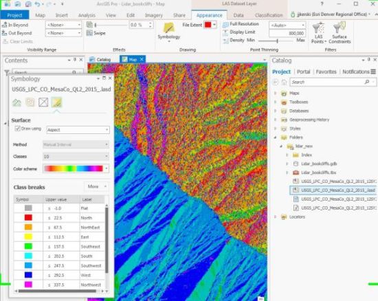
Working with Lidar data obtained from the USGS National Map data portal.
–Joseph Kerski
Contributors
Gallery


Recent Comments