Archive
Accessing USGS Topographic Maps on The Internet Archive – Archive.org
For years, I have used the Internet Archive (https://archive.org/about/) for many things, from archiving multimedia that I created for my story maps to looking up information on historical web pages through their Wayback Machine, (as well as for listening to some old wonderful sound recordings) and through those efforts became aware of the wealth of information on the site. And when I say wealth, I truly mean enormous – 279 billion web pages, 11 million books and texts, 4 million audio recordings (including 160,000 live concerts), 3 million videos (including 1 million Television News programs), 1 million images, and100,000 software programs. But did you know that The Internet Archive also houses some geospatial data? The Internet Archive, a 501(c)(3) non-profit organization that has existed since 1996, states that its mission is to “provide Universal Access to All Knowledge,” so it makes sense that some geospatial data for the public good is there.
Let’s focus here on the USGS topographic map data on The Internet Archive, also known as Digital Raster Graphics (DRGs). Start here for a list of these maps by state, and then underneath each state, a variety of search options are available. It isn’t the most intuitive unless you know the specific map name that you are looking for, so a topographic map index may still come in handy; a scanned version of these is not easy to come by, but one such archive is here. Formats include GeoTIFF, essential for use in a GIS.
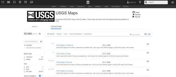
Interface on The Internet Archive for USGS Digital Raster Graphics.
While I still find the interface on the other main DRG archive, LibreMap, to be a bit easier to use, LibreMap is not maintained any longer, and is starting to return some errors during certain searches. The Esri USGS Historical Map Explorer, and the USGS TopoView, reviewed here, is more modern approach to obtaining topographic maps, with the added benefit of historical editions. USGS topographic maps are part of the set of basemaps available inside ArcGIS Online as data services, which is increasingly part of modern GIS workflows, rather than downloading the data and using it locally. Still another archive is that from Historical Aerials, which I reviewed here.
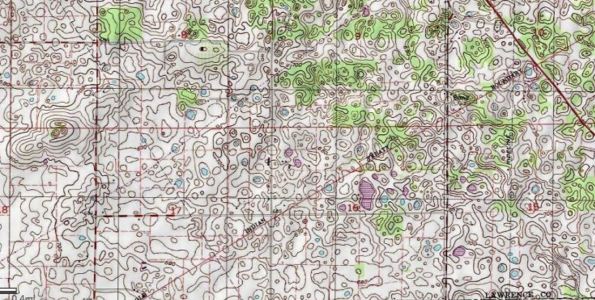
A section of my all-time favorite USGS topographic map, for Mitchell Indiana, simply because of the intricacies of the depression contours and disappearing streams in the magnificent karst landscape depicted.
Need access to thousands of historical aerials and topographic maps at your fingertips? Try www.historicaerials.com
Imagine having instant access to thousands upon thousands of historic aerial photographs and topographic maps to be able to examine change over time. Thanks to a resource called Historic Aerials, you do have this wealth of information at your fingertips. These aerials and maps, which go back 50, 60, and even 70 years or more, can be used for research, for instruction, for planning, and for other purposes. Being in the field of geography and GIS education, I can think of many disciplines in which this can be used — urban and rural geography most certainly, but also biology, environmental science, city planning, history, agriculture, and also in GIS courses. These resources foster spatial thinking about changes in time and space, from natural causes, such as volcanic eruptions or changes in river meanders, or from human causes, such as urbanization or the construction of reservoirs. And given the connection that often exists between human and natural changes, sometimes these causes are intertwined–the construction of jetties along barrier islands often influences the naturally occurring longshore sediment transport and the migration of the islands themselves, as can be seen by comparing the historic to modern aerials of Ocean City, Maryland, for example.
The interface for the Historic Aerials is intuitive and provides tools that allow the user to compare USGS topographic maps of various years as well as the aerials themselves. In the example below, I compare a 1958 with a 2009 aerial of a section of Grand Junction Colorado, before and after Interstate 70 and some surrounding housing was constructed. You can also use the spotlight tool to “see back in time” for wherever you pan your cursor, and you can turn on the streets to see where streets would one day be constructed on top of historical imagery.
The site comes from the Nationwide Environmental Title Research group, which has spent over 20 years collecting the worlds largest database of historical aerial images and topographical maps of the USA. Their sources include USGS and USDA imagery, several private collections, and they are continually acquiring more. All the imagery they collect is orthorectified to provide the data in a searchable and precise geo-locatable format. A print or digital image (for GIS users, GeoTIFF will be especially useful, delivered in lat-long coordinates, but JPG and PNG are also offered) of any of the maps or aerials is available. In addition, a subscription service allows anyone to access the site with the following advantages: Full screen viewer, no advertising, PDF builder, quick JPEG downloads, and multiple user accounts. I had a pleasant chat with the good people behind the site and found that their prices are quite reasonable. Their FAQ, forum, and tutorials make it clear that they are committed to user success with these resources, and there are human beings behind this site to help as well.
Quite frankly, during my years working at the USGS, I always dreamed that my agency would create something like this. Kudos to the HistoricAerials staff for making this a reality!

The interface for HistoricAerials.com is quite intuitive and allows for fascinating investigations back in time for lands across the USA.
Contributors
Gallery


Recent Comments