Crowdsourced Street Views with Mapillary
In our book and in this blog, we often focus on crowdsourcing, citizen science, and the Internet of Things. Mapillary, a tool that allows anyone to create their own street level photographs, map them, and share them via web GIS technology, fits under all three of these themes. The idea behind Mapillary is a simple but powerful one: Take photos of a place of interest as you walk, bicycle, or drive using the Mapillary mobile app. Next, upload the photos to Mapillary again using the app. Your photos will be mapped and connected with other Mapillary photos, and combined into street level photo views. Then you can explore your places and those from thousands of other users around the world.
Mapillary is part of the rapidly growing crowdsourcing movement, also known as citizen science, which seeks to generate “volunteered geographic information” content from ordinary citizens. Mapillary forms part of the Internet of Things (IoT) because people are acting as sensors across the global landscape using this technology. Mapillary is more than a set of tools–it is a community, with its own MeetUps and ambassadors. Mapillary is also a new Esri partner, and through an ArcGIS integration, local governments and other organizations can understand their communities in real-time, and “the projects they’re working on that either require a quick turnaround or frequent updates, can be more streamlined.” These include managing inventory and city assets, monitoring repairs, inspecting pavement or sign quality, and assessing sites for new train tracks. One of Mapillary’s goals was to provide street views in places where no Google Street Views exist.
Many organizations are using Mapillary: For example, the Missing Maps Project is a collaboration between the American Red Cross, British Red Cross, Médecins Sans Frontières-UK (MSF-UK, or Doctors Without Borders-UK), and the Humanitarian OpenStreetMap Team. The project aims to map the most vulnerable places in the developing world so that NGOs and individuals can use the maps and data to better respond to crises affecting these areas.
Using the discovery section on Mapillary, take a tour through the ancient city Teotihuacán in Mexico, Astypalaia, one of the Dodecanese Islands in Greece, Pompeii, or Antarctica. After you create an account and join the Mapillary community, you can access the live web map and click on any of the mapped tracks.
Mapillary can serve as an excellent way to help your students, clients, customers, or colleagues get outside, think spatially, use mobile apps, and use geotechnologies. Why stop at streets? You could map trails, as I have done while hiking or biking, or map rivers and lakes from a kayak or canoe. There is much to be mapped, explored, studied, and enjoyed. If you’d like extra help in mapping your campus, town, or field trip with Mapillary, send an email to Mapillary and let the team know what you have in mind. They can help you get started with ideas and tips (and bike mounts, if you need them).
For about two years, I have been using Mapillary to map trails and streets. I used the Mapillary app on my smartphone, generating photographs and locations as I hiked along. One of the trails that I mapped is shown below and also on the global map that everyone in the Mapillary community can access. I have spoken often with the Mapillary staff and salute their efforts.
We look forward to hearing your reactions and how you use this tool.
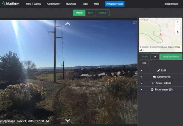
Mapillary view of a trail in Colorado USA that I created.
Contributors
Gallery


Recent Comments