The Coastal Atlas from the Maryland Department of Natural Resources
The Maryland Coastal Atlas serves up ocean use and resource data, coastal hazard and shoreline data, and near-shore and estuarine data. The purpose of the atlas is to make coastal related geospatial datasets available to agencies, researchers, and the general public for viewing and for performing basic overlays. Tools are being added to make the atlas more versatile for users to do analysis and to help simplify or select data important for different users’ needs. The list of layers is extensive; at least 100 items are included. But equally impressive is its ability to add dozens more layers from the MDiMapD database on such themes as agriculture, housing, demographics, hydrology, and much more.
The Atlas uses the Esri Web App Builder for its interactive map capabilities. One of my favorite things about the atlas is the user’s ability to add data to the web interface from ArcGIS Online, a URL, or a file of the user’s own creation. The site features unexpected helpful touches such as palette of drawing tools that makes the atlas a rich teaching tool, and transects that can be drawn in the map to analyze such things as erosion rates.
A few enhancements on the site could be done to make it more useful, such as an expansion of the fairly limited query tool and an explanation of how it can be used. I was puzzled how to close the transect results once I had created one, but this and other user interface questions were small; overall, the interface was intuitive. The Maryland Coastal Atlas provides an excellent addition to the other portals we have written about in this region, such as the Maryland iMap Data Catalog. We wrote about the state of Maryland’s GIS portal in the past, and the selected other data portals for the Chesapeake Bay.
The atlas uses the map services available from the Maryland GIS Portal and the iMap Open Data Catalog that we reviewed above. To obtain the data, go to the Maryland Data Catalog to download the data or get the API to use in an online mapping application. All of the Maryland Coastal Hazard datasets on the atlas are available through the data catalog but not all are downloadable. Here is an example of a dataset on the atlas shown in the iMap Data Catalog with the Download and API function available on the listing. Every layer is a REST service hosted by Maryland iMap, managed by the Geographical Information Office (GIO) and the state IT group (DOIT).
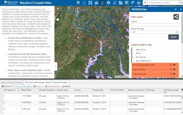
The Coastal Atlas from the Maryland Department of Natural Resources.
-
February 7, 2018 at 11:25 amThe Coastal Atlas from the Maryland Department of Natural Resources – GeoNe.ws
Contributors
Gallery


Recent Comments