Imagery: It is what it is: Well, not always.
Being critical of all data, including geospatial data, is a chief theme of this blog and our book: Use it wisely. Know where it came from. Know what has been done to it. Imagery has always been an important component of geospatial data, and today, it takes many forms, ranging from images taken on the ground with a phone or camera to those taken by webcams, UAVs, aircraft, satellites, and more. Doesn’t this imagery “tell it like it is” and is it therefore exempt from us casting a critical eye on it? I contend that no, images must be viewed critically so that you can determine if they are fit for your use in whatever project you are working on. For more, read below and see my video here.
As one example in a larger story, consider the example of the removal of individuals from 20th Century photographs in the USSR. But lest we think such image doctoring was a thing of the past, there are dozens of articles that arise in current web searches highlighting modern day image manipulation, from fashion magazines to science journals, some inadvertent, some on purpose, some for purposes to benefit society and some unfortunately to mislead. In the geospatial world, consider the image offsets on Google Maps in China that we wrote about not long ago.
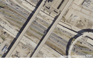
Let’s discuss another aspect of image manipulation. Consider the satellite images below. They cover many different dates and are derived from many different sources. But pay attention to what’s on–or off-the highways in the images. These images all cover the same location—Interstate 30 – 35E interchange on the southwest side of downtown Dallas Texas USA, known locally as the Mixmaster. Constructed between 1958 and 1962, you can spot, in some images, recent much-needed improvements due to the substantial increase in traffic volume in the past 60 years.
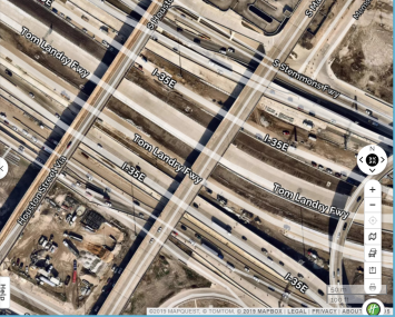
Study area in ArcGIS Online (first image) and Mapquest (second image).
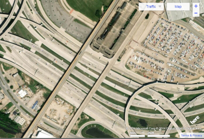
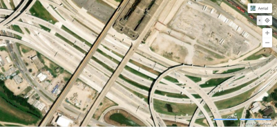
Study area in Yahoo maps (first image) and Bing maps (second image).
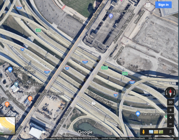
Study area in Google Maps (it appears the same way in Google Earth).
Notice anything missing on the Google Maps image? No traffic. This would be unheard of, day or night, in this busy part of one of the largest cities in the USA. Obviously, a vehicle-removal algorithm has been applied to the image. It is actually quite impressive, because the algorithm seems to only be applied to moving vehicles–cars, buses, trains–and not to stationary vehicles. No doubt it is applied to make the process of viewing and interpreting the now-clearer imagery easier. Interestingly, the moving-vehicle removal seems to only, at the present time, be present in running Google Maps on the web on a tablet or laptop: Running the Google Maps app on a smartphone shows moving vehicles (below).

Study area in Google Maps app on smartphone.
Key takeaway points and teachable moments here include: (1) Images that can be obtained in web mapping services, in geodatabases, and portals should not be considered the same view that would be seen if someone were to be peering over the side of a UAV, airplane, spacecraft, or standing next to a webcam when the image was captured. They can and are manipulated for a variety of purposes. They need to be viewed critically. At the same time, we can marvel and appreciate the many choices we have nowadays in imagery for use in geospatial analysis. (2) The machine learning and artificial intelligence techniques applied to imagery are further evidence for the enterprise nature of geotechnologies: GIS is increasingly connected to mainstream IT trends and innovations.
–Joseph Kerski
Leave a comment
Contributors
Gallery


Take home points on imagery piece are spot-on. Made me aware of the coincidence in imagery: the most vital layer is the most manipulable, right in there with subliminal advertising.
In one of my lectures on remote sensing, I stress the ‘solution’ in resolution, i.e. that we must think critically about the problem to be solved, rather than pitching for the highest resolution and highest budget…Pleasant morning, Joe. Paul
Thanks Paul! I am glad you found this helpful! Keep in touch.
On an additional note, also be aware of how the brain perceives imagery, as well. There are many videos along the lines of “can you trust your eyes” along these lines, such as: https://ed.ted.com/best_of_web/bb6LomeX#review
Joseph–Thank you for echoing the echo.
Our 2019 exchange rings truer than ever. Trust your eyes? Hm…Keep going: Trust your news?
From pillars of instrument flight:
* Instument Cross-Check * Instument Interpretion * Aircraft Control
Order is critical. The process is cyclical.
No, you cannot trust your eyes. No, you cannot trust your Instruments, unless your Cross-check indicates proper functioning of Instruments. No, do not attempt to control [anything] until your Instrument Interpretation is clear and actionable. Begin again.
Thanks Paul. Keep up the good work you are doing. –Joseph Kerski
I very much appreciate you publishing this article ! Thank you for sharing and for all you do.